STAC Item Metadata
Last updated: December 1, 2022
Overview
ARD order deliveries include a STAC Item Metadata file describing the tile and its assets, in JSON format. The item schema adheres to the version of the STAC item specification referred to in the document. STAC and custom extensions are used to extend the metadata.
Extensions
Extensions allow the STAC specification to describe data in more specific terms. Maxar ARD uses extensions designed for describing satellite imagery and adds a custom "tile" extension for describing fields specific to the data within the grid tile bounds.
| Extension | Type | Field name prefix | Description |
|---|---|---|---|
| electro-optical | STAC | eo |
Data that represents a snapshot of the Earth for a single date and time. It could consist of multiple spectral bands in any part of the electromagnetic spectrum. |
| Projection | STAC | proj |
Describes items whose assets are in a geospatial projection. |
| View Geometry | STAC | view |
Adds metadata related to angles of sensors and other radiance angles that affect the view of resulting data. |
| Raster | STAC | raster |
Describes raster assets at band level (one or multiple). |
| Grid | STAC | grid |
Provides fields related to gridded data products. |
| Classification | STAC | classification |
Used when one or more unique coded integer values are present within a raster asset or band therein. These coded values translate to classes of data with verbose descriptions. |
| tile | custom | tile |
Data specific to imagery tiles. |
Item fields
This table describes the primary metadata for a tile. Additional metadata fields for objects are listed in separate tables.
| Field | Type | Description | Example |
|---|---|---|---|
| type | string | The type of the GeoJSON object. The type for a STAC item is "feature". | "type": "Feature" |
| stac_version | string | The STAC version used by the item. | "stac_version": "1.0.0" |
| stac_extensions | string | Extensions implemented with the STAC item. ARD implements the projection, geometry, and electro-optical(eo) extensions. | "stac_extensions": ["https://stac-extensions.github.io/view/v1.0.0/schema.json", "https://stac-extensions.github.io/projection/v1.0.0/schema.json", "https://stac-extensions.github.io/eo/v1.0.0/schema.json"] |
| id | string | The unique identifier for an item. The ID for the ARD item is utm_zone/quadkey/acquisitionID. | "id": "11/031311311232/104001006D0BB300" |
| bbox | number | The bounding box coordinates for the item, projected to wgs84. | "bbox": [-117.29404086049149, 32.89643160060904, -117.26563783226379, 32.94040782110711] |
| geometry | GeoJSON geometry object | The geometry coordinates for the polygon, projected to wgs84. | "geometry": |
| properties | object | Additional metadata for the item. | See Properties table below. |
| links | object | A list of links to resources and additional URLs. | See Links table below. |
| assets | object | A list of assets and their metadata. Assets are downloadable objects for the item. | See Assets table below. |
| collection | string | The unique identifier for the STAC collection referenced in this item. The unique identifier is the AcquisitionID. | "collection": "104001006D0BB300" |
Properties object
The properties object lists additional metadata for the item. When a property is prepended by a {name}:, this indicates the STAC extension the property is derived from.
| Field | Type | Description | Example |
|---|---|---|---|
| datetime | string | An ISO-8601-formatted string to indicate the imagery date. To indicate a range use a / to separate two date strings, e.g. “2019-10-25T09:00:00Z/2020-10-26T13:00:00Z”; for open-ended ranges use .. as the date e.g. "2019-10-25T09:00:00Z/.. | "datetime": "2021-09-21 18:34:57Z" |
| platform | string | The satellite that acquired the image. | "platform": "WV03" |
| gsd | number | The spatial resolution, or ground sampling distance, of the sensor that acquired the image, stated in meters. | "gsd": 0.32 |
| ard_metadata_version | string | The version number assigned to ARD metadata. | "ard_metadata_version": "0.0.1" |
| catalog_id | string | The unique identifier for the item, as assigned by the provider, Maxar. This is also referred to as the "acquisition ID". | "catalog_id": "104001006D0BB300"0 |
| utm_zone | number | The Universal Transverse Mercator(UTM) coordinate system number assigned to the zone where the item is located. | "utm_zone": 11 |
| proj:epsg | integer | The coordinate reference system used by the asset data. Maxar ARD uses "epsg". | "proj:epsg": 32611 |
| proj: geometry | GeoJSON geometry object | Defines the footprint of this Item in native UTM projection. | see example below this table. |
| proj:bbox | number | Bounding box of the Item in the asset coordinate reference system (CRS), in 2 or 3 dimensions; native UTM projection. | see example below this table. |
| quadkey | string | The address where the item is located on the Maxar grid. | "quadkey": "031311311232" |
| tile:data_area | number | The square kilometer area of the tile with data. | "tile:data_area": 12.8 |
| tile:clouds_area | number | The square kilometer area of the tile that has clouds. | "tile:clouds_area": 0 |
| tile:clouds_percent | number | The percentage of the tile that is covered by clouds. | "tile:clouds_percent": 0 |
| view:off_nadir | number | The angle from the sensor between nadir (straight down) and the scene center. Measured in degrees (0-90). | "view:off_nadir": 13.0 |
| view:azimuth | number | Viewing azimuth angle. The angle measured from the sub-satellite point (point on the ground below the platform) between the scene center and true north. Measured clockwise from north in degrees (0-360). | "view:azimuth": 153.5 |
| view:incidence_angle | number | The incidence angle is the angle between the vertical (normal) to the intercepting surface and the line of sight back to the satellite at the scene center. Measured in degrees (0-90). | "view:incidence_angle": 74.7 |
| view:sun_azimuth | number | Sun azimuth angle. From the scene center point on the ground, this is the angle between truth north and the sun. Measured clockwise in degrees (0-360). | "view:sun_azimuth": 150.7 |
| view:sun_elevation | number | Sun elevation angle. The angle from the tangent of the scene center point to the sun. Measured from the horizon in degrees (-90-90). Maxar ARD is not available with a sun elevation of less than 5 degrees (nighttime imagery). | "view:sun_elevation": 54.1 |
| hd | boolean | Indicates that HD imagery has been enabled for this selection. If HD imagery is not ordered or it is ordered in a restricted AOI, this field will not exist. | "hd": true |
| hd_restricted_area_intersection | boolean | This will only appear if you've tried to request HD imagery in a restricted AOI. | "hd_restricted_area_intersection": true |
Proj: geometry and bbox examples
"proj:geometry": {
    "type": "Polygon",
    "coordinates": [
        [
            [472513.427734375, 3644718.9331054688],
            [472504.2724609375, 3639843.75],
            [475156.25, 3639843.75],
            [475156.25, 3644640.8081054688],
            [472513.427734375, 3644718.9331054688]
        ]
    ]
}
"proj:bbox": [472504.2724609375, 3639843.75, 475156.25, 3644718.9331054688]
Links Object
The links object provides URLs to metadata files and shows their relationship to the file.
| Field | Description | Example |
|---|---|---|
| rel | The relationship between the link and the entity it describes. See "relationship" table below. | "rel": "collection" |
| href | The URL for the linked file. | "href": "../../../acquisition_collections/104001006D0BB300_collection.json" |
| type | The type for the linked file. | "type": "application/json" |
Relationship types
| Type | Description | Example |
|---|---|---|
| collection | URL to the acquisition collection file. | "href": "../../../acquisition_collections/104001006D0BB300_collection.json" |
| parent | URL to the acquisition collection file. | "href": "../../../acquisition_collections/104001006D0BB300_collection.json" |
| root | URL to the order collection file. | "href": "../../../order_collections/5681790434919305322_root_collection.json" |
Note: The "collection" and "parent" links go to the same file. Both are listed for STAC compliance and tool compatibility.
Assets object
The Assets object lists all of the downloadable files that are part of the order delivery. For some assets, additional metadata for the file is included here.
The asset list includes data masks and image files.
Data masks
| Mask | Asset name | Description | File type | Filename |
|---|---|---|---|---|
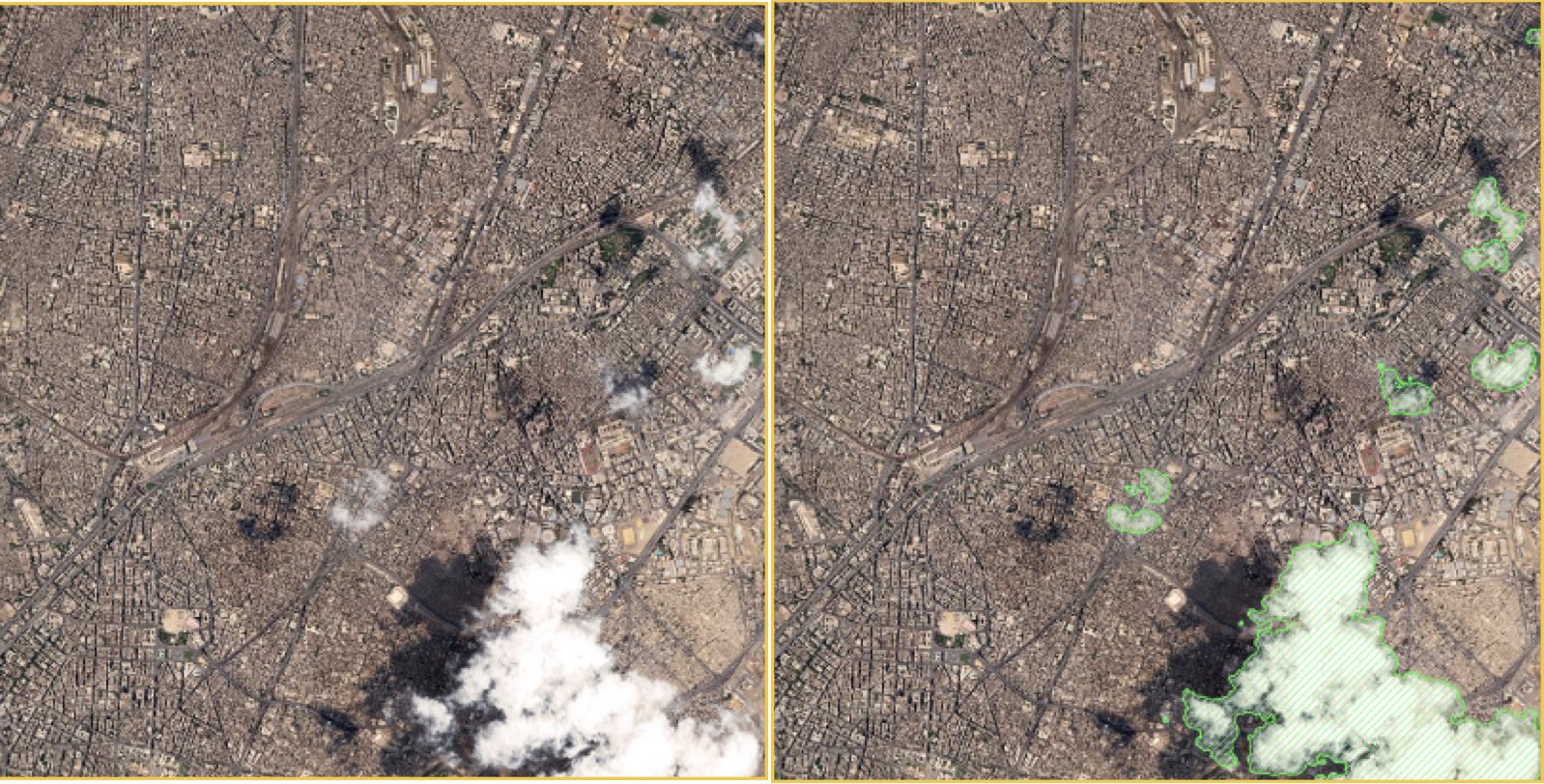
| Cloud/Cloud Shadow Coverage Raster | cloud-mask-raster | Identifies clouds and cloud shadow pixels. | raster | {acquisitionID}-clouds.tif |
| Cloud Polygons | cloud-mask | Traces the boundaries of identified cloud polygons. | vector | {acquisitionID}-cloud-mask.gpkg |
| Cloud Shadow Polygons | cloud-shadow-mask | Traces the boundaries of identified cloud shadows. | vector | {acquisitionID}-cloud-shadow-mask.gpkg |
| Data Mask | data-mask | Identifies all pixels classified as "data" in the raster image and vectorizes those pixels as a GeoPackage. Pixels are either classified as "data" or "no data". | vector | {acquisitionID}-data-mask.gpkg |
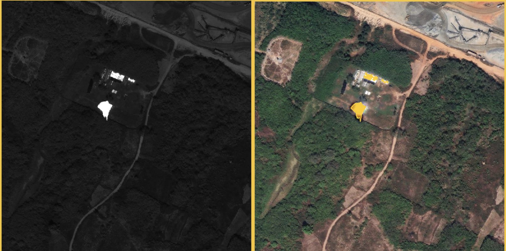
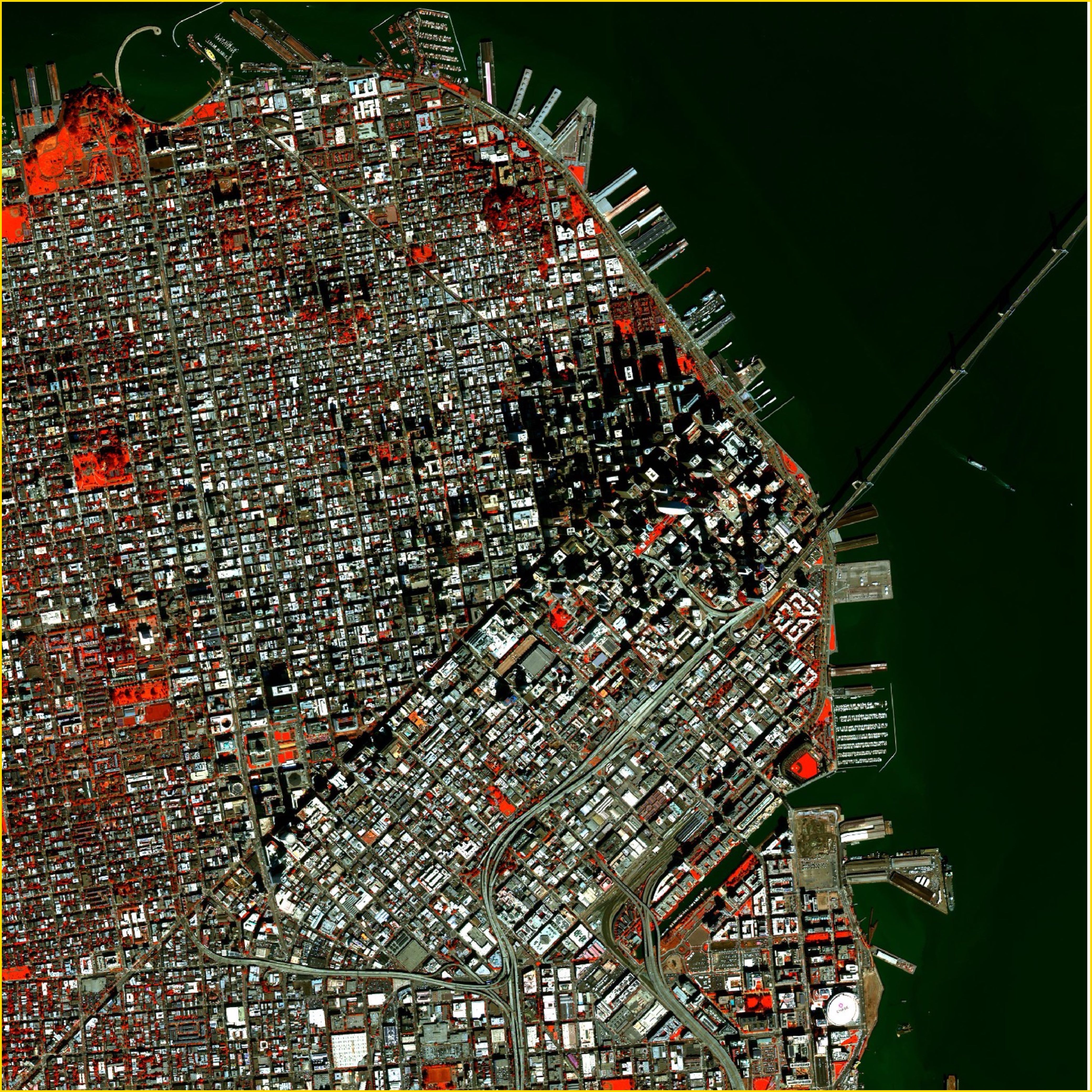
| Healthy Vegetation Mask | healthy-vegetation-mask-raster | Binary raster indicating green, healthy vegetation pixels. | raster | {acquisitionID}-healthy-vegetation.tif |
| Healthy Vegetation Polygons | healthy-vegetation-mask | Polygons that indicate the detected boundaries of green, healthy vegetation. | vector | {acquisitionID}-healthy-vegetation-mask.gpkg |
| MS Pixel Saturation Mask | ms-saturation-mask-raster | Identifies saturated pixels in a 4 or 8-band multispectral image. | raster | {acquisitionID}-ms-saturation.tif |
| MS Pixel Saturation Polygons | ms-saturation-mask | Traces the boundaries of identified saturated pixels in a multispectral image. | vector | {acquisitionID}-ms-saturation-mask.gpkg |
| Pan Flare Mask | pan-flare-mask-raster | Detected flared pixels from panchromatic images. | raster | {acquisitionID}-pan-flare.tif |
| Pan Flare Polygons | pan-flare-mask | Polygons that indicate the detected boundaries of flares. | vector | {acquisitionID}-pan-flare-mask.gpkg |
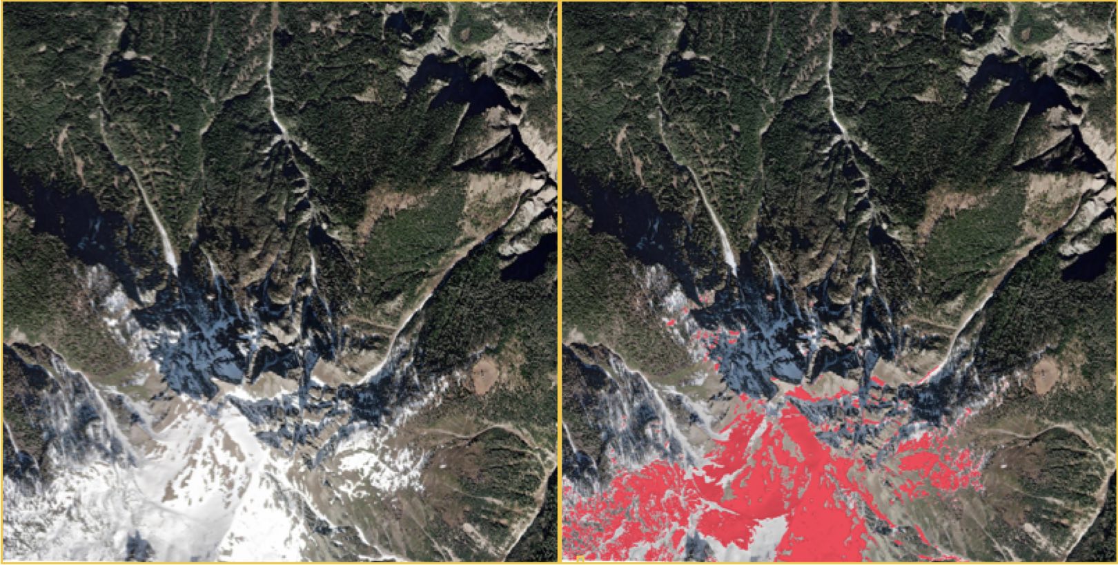
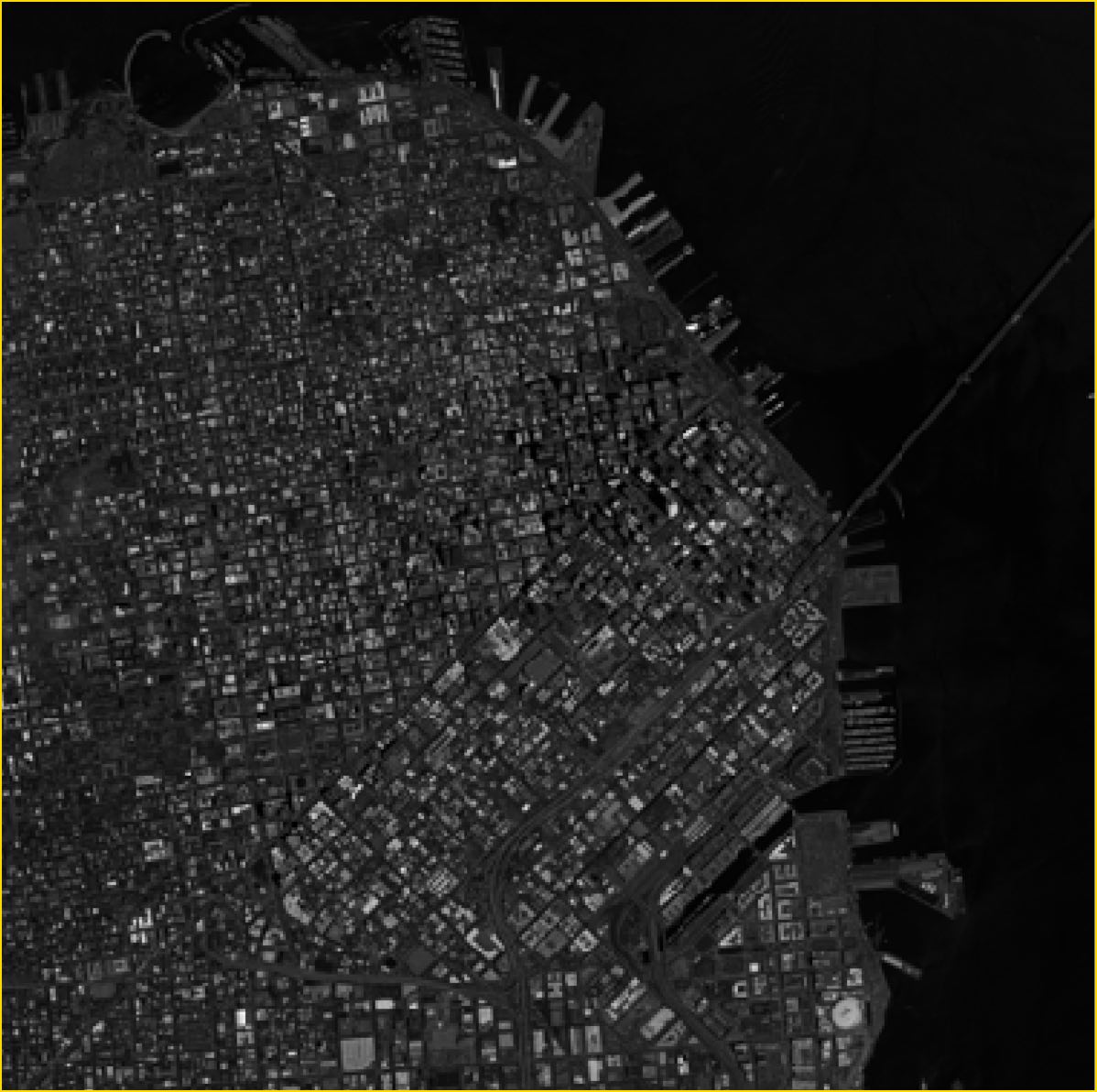
| Terrain Shadows Mask | terrain-shadow-mask-raster | Identifies terrain shadow pixels. | raster | {acquisitionID}-terrain-shadows.tif |
| Terrain Shadows Polygon | terrain-shadow-mask | Traces the boundaries of detected terrain shadows. | vector | {acquisitionID}-terrain-shadow-mask.gpkg |
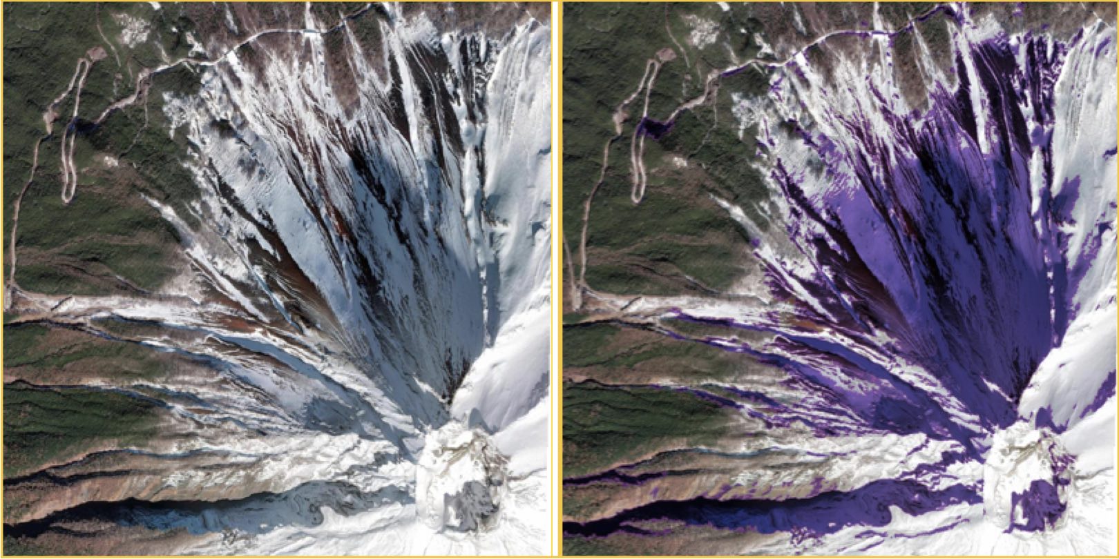
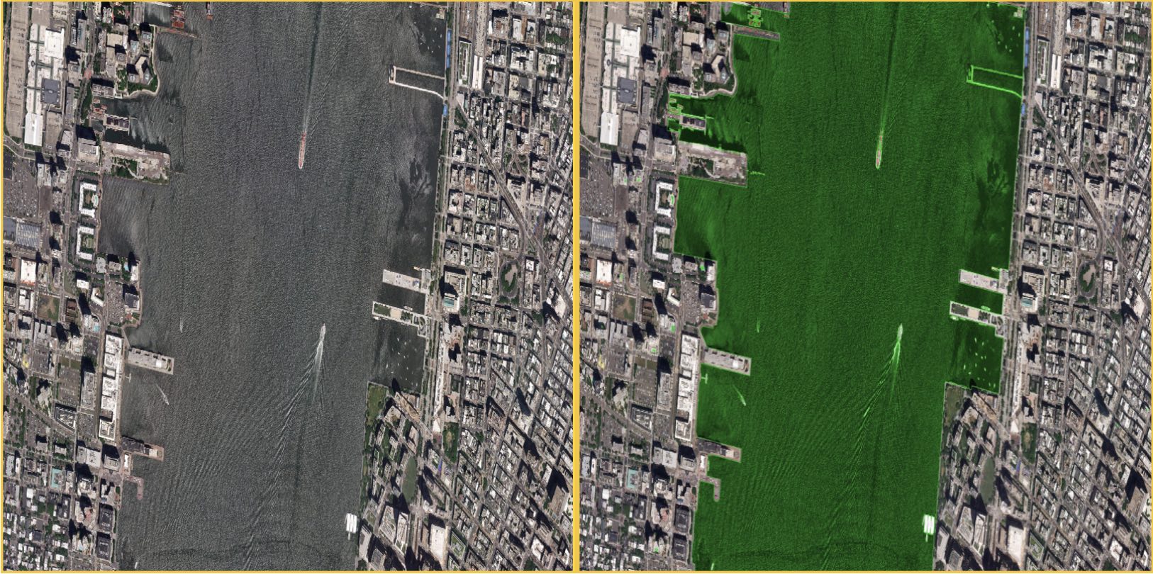
| Water Mask | water-mask-raster | Detects pixels for bodies of water and swimming pools. | raster | {acquisitionID}-water.tif |
| Water Polygons | water-mask | Traces the boundaries of bodies of water and swimming pools. | vector | {acquisitionID}-water-mask.gpkg |
Note: Worldview-1 order deliveries include only the Cloud and Cloud Shadows masks.
Image files
| Image file | Asset Name | Description | Filename |
|---|---|---|---|
| Multispectral Image | ms_analytic | A 4 or 8-band multispectral image in GeoTiff format. | {acquisitionID}-ms.tif |
| Panchromatic Image | pan_analytic | A single-band panchromatic image in GeoTiff format. | {acquisitionID}-pan.tif |
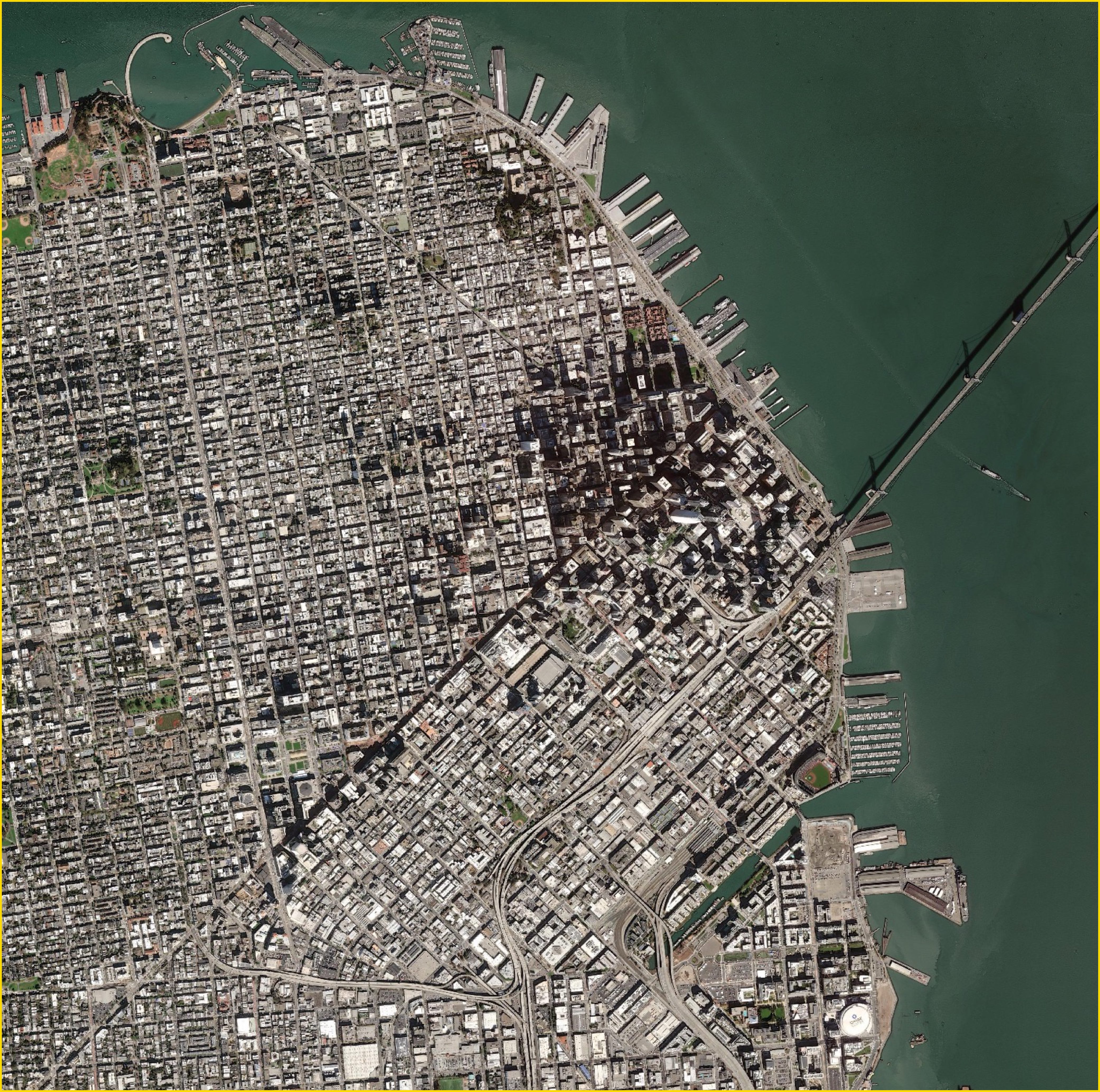
| Visual Image | visual | An 8-bit image in GeoTiff format. | {acquisitionID}-visual.tif |
Note: The multispectral (ms_analytic) file is not delivered with WorldView-1 imagery.
Asset fields
Assets include the following fields:
| Field name | Description | Example |
|---|---|---|
| type | The file type. | "type": "image/tiff; application=geotiff; profile=cloud-optimized" |
| title | The title of the asset. The title is used to reference this file in documentation. | "Cloud/Cloud Shadow Coverage Raster" |
| roles | A standardized way to understand the type and intent of an asset. See asset roles. | "roles": ["cloud","cloud-shadow"] |
| description | A one-line description of the raster asset. Vector assets do not have a listed description. | "thematic raster, 0 -> no data, 1 -> clear, 2 -> cloud, 3 -> cloud shadow" |
| href | The URL reference for the asset. | "href": "./104001006D0BB300-clouds.tif" |
Additional raster metadata
Additional STAC metadata is list for raster assets. The descriptions are taken from the Projection and electro-optical STAC extension specifications.
| Field name | Type | Description | Example |
|---|---|---|---|
| proj:bbox | number | The bounding box of the Item in the asset CRS in 2 or 3 dimensions. | "proj:bbox": [469843.75, 3639843.75, 475156.25, 3645156.25] |
| proj:shape | integer | The number of pixels in Y and X directions for the default grid. | [2176, 2176] |
| proj:transform | number | The affine transformation coefficients for the default grid. | [2.44140625, 0.0, 469843.75, 0.0, -2.44140625, 3645156.25, 0.0, 0.0, 1.0] |
| eo:bands | object | An array of available bands for the asset. | [{"name": "BAND_CM","description": "Clouds/Cloud Shadows Mask" |
| raster:bands | object | Raster:bands classify data values in the Clouds and Cloud Shadows mask raster. | {"value": 1,"name": "clear","description": "Clear of clouds or shadows"} |
eo:bands
The eo:bands object lists the bands available for a particular image asset. This table lists eo band names associated with ARD image assets. Color bands are provided for multispectral imagery.
Spectral eo:bands
Maxar's multispectral imagery is captured with either 4 or 8 bands, depending on the sensor.
4-band multispectral imagery has the following bands:
| band name | common name | description |
|---|---|---|
| BAND_B | blue | Blue |
| BAND_G | green | Green |
| BAND_R | red | Red |
| BAND_IR | nir08 | Near Infrared 1 |
8-band multispectral imagery has the following bands:
| band name | common name | description |
|---|---|---|
| BAND_B | blue | Blue |
| BAND_C | coastal | Coastal blue |
| BAND_G | green | Green |
| BAND_R | red | Red |
| BAND_IR | nir08 | Near Infrared 1 |
| BAND_Y | yellow | Yellow |
| BAND_RE | rededge | Red Edge 1 |
| BAND_N2 | nir09 | Near Infrared 2 |
Panchromatic (black and white) imagery has a single band:
| band name | description |
|---|---|
| BAND_P | pan |
Visual RGB imagery has the following 3 bands:
| band name | common name | description |
|---|---|---|
| BAND_R | red | Red |
| BAND_G | green | Green |
| BAND_B | blue | Blue |
Visual panchromatic imagery has the following single band:
| band name | description |
|---|---|
| BAND_P_V | Pan Visual |
Raster Bands
The Cloud and Cloud Shadows mask raster asset has a set of raster bands.
| value | name | description |
|---|---|---|
| 0 | nodata | NoData |
| 1 | clear | Clear of clouds or shadows |
| 2 | cloud | Clouds |
| 3 | cloud_shadow | Cloud shadows |
Example 0rder STAC item metadata file
{
    "type": "Feature",
    "stac_version": "1.0.0",
    "stac_extensions": [
        "https://stac-extensions.github.io/view/v1.0.0/schema.json",
        "https://stac-extensions.github.io/projection/v1.0.0/schema.json",
        "https://stac-extensions.github.io/eo/v1.0.0/schema.json",
        "https://stac-extensions.github.io/raster/v1.1.0/schema.json",
        "https://stac-extensions.github.io/grid/v1.0.0/schema.json",
        "https://stac-extensions.github.io/classification/v1.1.0/schema.json"
    ],
    "id": "38/120202332110/03cf5011-7fd0-49ab-8bcf-36d7e2a1075f-inv",
    "properties": {
        "datetime": "2018-08-10 07:38:32Z",
        "platform": "WV04",
        "gsd": 0.36,
        "ard_metadata_version": "0.0.1",
        "catalog_id": "03cf5011-7fd0-49ab-8bcf-36d7e2a1075f-inv",
        "utm_zone": 38,
        "quadkey": "120202332110",
        "view:off_nadir": 23.2,
        "view:azimuth": 130.9,
        "view:incidence_angle": 64.4,
        "view:sun_azimuth": 123.9,
        "view:sun_elevation": 68.0,
        "proj:epsg": 32638,
        "proj:geometry": {
            "type": "Polygon",
            "coordinates": [[[773061.5007680104, 3240156.25], [773090.2523345766, 3238957.8062060564], [772117.9930662059, 3238934.5298007736], [772088.7875557052, 3240156.25], [773061.5007680104, 3240156.25]]]
        },
        "grid:code": "MXRA-Z38-120202332110",
        "proj:bbox": [772088.7875557052, 3238934.5298007736, 773090.2523345766, 3240156.25],
        "tile:data_area": 1.1,
        "tile:clouds_area": 0.0,
        "tile:clouds_percent": 0
    },
    "bbox": [47.8, 29.25, 47.81, 29.26101900914853],
    "geometry": {
        "type": "Polygon",
        "coordinates": [[[47.81, 29.260808473224973], [47.81, 29.25], [47.8, 29.25], [47.8, 29.26101900914853], [47.81, 29.260808473224973]]]
    },
    "links": [
        {
            "rel": "collection",
            "href": "../../../acquisition_collections/03cf5011-7fd0-49ab-8bcf-36d7e2a1075f-inv_collection.json",
            "type": "application/json"
        },
        {
            "rel": "parent",
            "href": "../../../acquisition_collections/03cf5011-7fd0-49ab-8bcf-36d7e2a1075f-inv_collection.json",
            "type": "application/json"
        },
        {
            "rel": "root",
            "href": "../../../order_collections/20220711cbteststaceochangev1_root_collection.json",
            "type": "application/json"
        }
    ],
    "assets": {
        "data-mask": {
            "type": "application/geopackage+sqlite3",
            "title": "Data Mask",
            "href": "./03cf5011-7fd0-49ab-8bcf-36d7e2a1075f-inv-data-mask.gpkg",
            "roles": ["data-mask"]
        },
        "cloud-mask-raster": {
            "type": "image/tiff; application=geotiff; profile=cloud-optimized",
            "title": "Cloud/Cloud Shadow Coverage Raster",
            "description": "thematic raster, 0 -> no data, 1 -> clear, 2 -> cloud, 3 -> cloud shadow",
            "href": "./03cf5011-7fd0-49ab-8bcf-36d7e2a1075f-inv-clouds.tif",
            "proj:bbox": [769843.75, 3234843.75, 775156.25, 3240156.25],
            "proj:shape": [2176, 2176],
            "proj:transform": [2.44140625, 0.0, 769843.75, 0.0, -2.44140625, 3240156.25, 0.0, 0.0, 1.0],
            "raster:bands": [
                {
                    "classification:classes": [
                        {
                            "value": 0,
                            "name": "nodata",
                            "description": "NoData"
                        },
                        {
                            "value": 1,
                            "name": "clear",
                            "description": "Clear of clouds or shadows"
                        },
                        {
                            "value": 2,
                            "name": "cloud",
                            "description": "Clouds"
                        },
                        {
                            "value": 3,
                            "name": "cloud_shadow",
                            "description": "Cloud shadows"
                        }
                    ]
                }
            ],
            "roles": ["cloud", "cloud-shadow"]
        },
        "cloud-mask": {
            "type": "application/geopackage+sqlite3",
            "href": "./03cf5011-7fd0-49ab-8bcf-36d7e2a1075f-inv-cloud-mask.gpkg",
            "title": "Cloud Polygons",
            "roles": ["cloud"]
        },
        "cloud-shadow-mask": {
            "type": "application/geopackage+sqlite3",
            "href": "./03cf5011-7fd0-49ab-8bcf-36d7e2a1075f-inv-cloud-shadow-mask.gpkg",
            "title": "Cloud Shadow Polygons",
            "roles": ["cloud-shadow"]
        },
        "healthy-vegetation-mask-raster": {
            "type": "image/tiff; application=geotiff; profile=cloud-optimized",
            "href": "./03cf5011-7fd0-49ab-8bcf-36d7e2a1075f-inv-healthy-vegetation.tif",
            "title": "Healthy Vegetation Mask",
            "proj:bbox": [769843.75, 3234843.75, 775156.25, 3240156.25],
            "proj:shape": [3741, 3741],
            "proj:transform": [1.4200748462977812, 0.0, 769843.75, 0.0, -1.4200748462977812, 3240156.25, 0.0, 0.0, 1.0],
            "roles": ["data"]
        },
        "healthy-vegetation-mask": {
            "type": "application/geopackage+sqlite3",
            "href": "./03cf5011-7fd0-49ab-8bcf-36d7e2a1075f-inv-healthy-vegetation-mask.gpkg",
            "title": "Healthy Vegetation Polygons",
            "roles": ["data"]
        },
        "ms_analytic": {
            "type": "image/tiff; application=geotiff; profile=cloud-optimized",
            "title": "Multispectral Image",
            "href": "./03cf5011-7fd0-49ab-8bcf-36d7e2a1075f-inv-ms.tif",
            "proj:bbox": [769843.75, 3234843.75, 775156.25, 3240156.25],
            "proj:shape": [3741, 3741],
            "proj:transform": [1.4200748462977812, 0.0, 769843.75, 0.0, -1.4200748462977812, 3240156.25, 0.0, 0.0, 1.0],
            "eo:bands": [
                {
                    "name": "BAND_B",
                    "common_name": "blue",
                    "description": "Blue"
                },
                {
                    "name": "BAND_G",
                    "common_name": "green",
                    "description": "Green"
                },
                {
                    "name": "BAND_R",
                    "common_name": "red",
                    "description": "Red"
                },
                {
                    "name": "BAND_N",
                    "common_name": "nir08",
                    "description": "Near Infrared 1"
                }
            ],
            "roles": ["data"]
        },
        "ms-saturation-mask-raster": {
            "type": "image/tiff; application=geotiff; profile=cloud-optimized",
            "title": "Multispectral Pixel Saturation Mask",
            "href": "./03cf5011-7fd0-49ab-8bcf-36d7e2a1075f-inv-ms-saturation.tif",
            "proj:bbox": [769843.75, 3234843.75, 775156.25, 3240156.25],
            "proj:shape": [3741, 3741],
            "proj:transform": [1.4200748462977812, 0.0, 769843.75, 0.0, -1.4200748462977812, 3240156.25, 0.0, 0.0, 1.0],
            "roles": ["saturation"]
        },
        "ms-saturation-mask": {
            "type": "application/geopackage+sqlite3",
            "href": "./03cf5011-7fd0-49ab-8bcf-36d7e2a1075f-inv-ms-saturation-mask.gpkg",
            "title": "MS Pixel Saturation Polygons",
            "roles": ["saturation"]
        },
        "pan_analytic": {
            "type": "image/tiff; application=geotiff; profile=cloud-optimized",
            "title": "Panchromatic Image",
            "href": "./03cf5011-7fd0-49ab-8bcf-36d7e2a1075f-inv-pan.tif",
            "proj:bbox": [769843.75, 3234843.75, 775156.25, 3240156.25],
            "proj:shape": [14964, 14964],
            "proj:transform": [0.3550187115744453, 0.0, 769843.75, 0.0, -0.3550187115744453, 3240156.25, 0.0, 0.0, 1.0],
            "eo:bands": [
                {
                    "name": "BAND_P",
                    "description": "Pan"
                }
            ],
            "roles": ["data"]
        },
        "pan-flare-mask-raster": {
            "type": "image/tiff; application=geotiff; profile=cloud-optimized",
            "href": "./03cf5011-7fd0-49ab-8bcf-36d7e2a1075f-inv-pan-flare.tif",
            "title": "Pan Flare Mask",
            "proj:bbox": [769843.75, 3234843.75, 775156.25, 3240156.25],
            "proj:shape": [14964, 14964],
            "proj:transform": [0.3550187115744453, 0.0, 769843.75, 0.0, -0.3550187115744453, 3240156.25, 0.0, 0.0, 1.0],
            "roles": ["data"]
        },
        "pan-flare-mask": {
            "type": "application/geopackage+sqlite3",
            "href": "./03cf5011-7fd0-49ab-8bcf-36d7e2a1075f-inv-pan-flare-mask.gpkg",
            "title": "Pan Flare Polygons",
            "roles": ["data"]
        },
        "terrain-shadow-mask-raster": {
            "type": "image/tiff; application=geotiff; profile=cloud-optimized",
            "href": "./03cf5011-7fd0-49ab-8bcf-36d7e2a1075f-inv-terrain-shadows.tif",
            "title": "Terrain Shadow Mask",
            "proj:bbox": [769843.75, 3234843.75, 775156.25, 3240156.25],
            "proj:shape": [3741, 3741],
            "proj:transform": [1.4200748462977812, 0.0, 769843.75, 0.0, -1.4200748462977812, 3240156.25, 0.0, 0.0, 1.0],
            "roles": ["terrain-shadow"]
        },
        "terrain-shadow-mask": {
            "type": "application/geopackage+sqlite3",
            "href": "./03cf5011-7fd0-49ab-8bcf-36d7e2a1075f-inv-terrain-shadow-mask.gpkg",
            "title": "Terrain Shadow Polygons",
            "roles": ["terrain-shadow"]
        },
        "visual": {
            "type": "image/tiff; application=geotiff; profile=cloud-optimized",
            "title": "Visual Image",
            "href": "./03cf5011-7fd0-49ab-8bcf-36d7e2a1075f-inv-visual.tif",
            "proj:bbox": [769843.75, 3234843.75, 775156.25, 3240156.25],
            "proj:shape": [17408, 17408],
            "proj:transform": [0.30517578125, 0.0, 769843.75, 0.0, -0.30517578125, 3240156.25, 0.0, 0.0, 1.0],
            "eo:bands": [
                {
                    "name": "BAND_R",
                    "common_name": "red",
                    "description": "Red"
                },
                {
                    "name": "BAND_G",
                    "common_name": "green",
                    "description": "Green"
                },
                {
                    "name": "BAND_B",
                    "common_name": "blue",
                    "description": "Blue"
                }
            ],
            "roles": ["visual"]
        },
        "water-mask-raster": {
            "type": "image/tiff; application=geotiff; profile=cloud-optimized",
            "href": "./03cf5011-7fd0-49ab-8bcf-36d7e2a1075f-inv-water.tif",
            "title": "Water Mask",
            "proj:bbox": [769843.75, 3234843.75, 775156.25, 3240156.25],
            "proj:shape": [3741, 3741],
            "proj:transform": [1.4200748462977812, 0.0, 769843.75, 0.0, -1.4200748462977812, 3240156.25, 0.0, 0.0, 1.0],
            "roles": ["water-mask"]
        },
        "water-mask": {
            "type": "application/geopackage+sqlite3",
            "href": "./03cf5011-7fd0-49ab-8bcf-36d7e2a1075f-inv-water-mask.gpkg",
            "title": "Water Polygons",
            "roles": ["water-mask"]
        }
    },
    "collection": "03cf5011-7fd0-49ab-8bcf-36d7e2a1075f-inv"
}